Hello Everybody (dr. Nick accent / Simpsons)
I am a year in on my project and I seem to have stumbled on to what could be a very severe issue. I am positive it is something I am simply overlooking, but as a scientist (and not the data kind!) I am a bit out of my depth here. I think my coding prowess can be summed up thusly: " even a broken clock is right twice a day"
That being said, Here’s some background.
My software is for mapping raw data counts over a geo-rectified image. pretty simple, probably shouldn’t have taken me a year to get to this point, but here I am. The software allows a user to load an image, typically a screen grab from google maps, but it can be anything really. The user can then geo-rectify it using a subroutine.
I think My worldfiles are right, but I have two questions.
-
If the user is using google maps imagery, but the AXmap1 projection is set to projection_WGS84, will that cause an error when displaying the .JPG/.JGW?
-
If you were mathematically computing the Worldfile, using visual basic, How would YOU do it?
I’ll show you below what I am doing and explain it best I can.
Here is an image that first led me to believe there was an issue with the way my software displays the image.
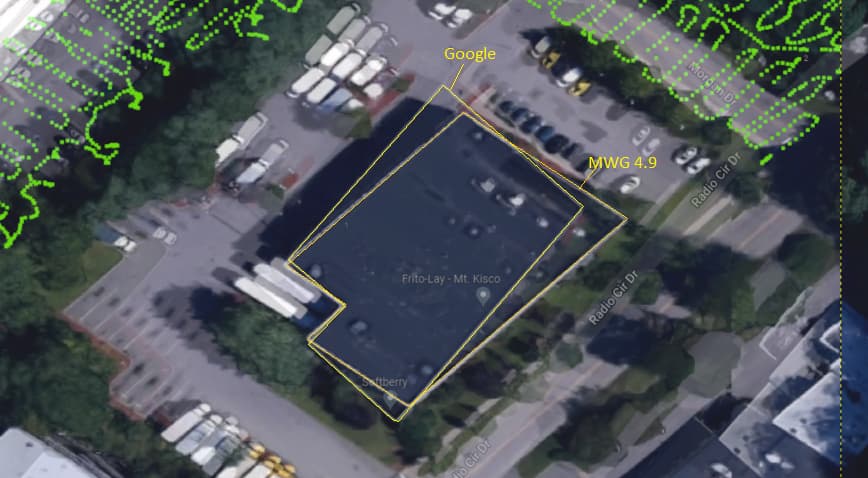
Here you can see I have drawn an outline around the same image of a building, just overlaid in GIMP and the Opacity adjusted so we can see both at the same time. Clearly there is a bit of a rotation.

Here you can see a similar issue. There seems to be a bit of a rotation and a scaling mismatch.
    For j = 2 To 100
        If CalCoord(j, 1) = 0 Then
            Exit For
        End If
        If (CalCoord(j, 3) - CalCoord(j - 1, 3)) = 0 Or (CalCoord(j, 4) - CalCoord(j - 1, 4)) = 0 Then
            MsgBox("Error: choose wider spaced points", vbOKOnly)
            Erase CalCoord
            Exit For
        End If
        If j = 2 Then
            LongXperPixel = Math.Abs((CalCoord(j, 1) - CalCoord(j - 1, 1)) / (CalCoord(j, 3) - CalCoord(j - 1, 3)))
            LatYperPixel = Math.Abs((CalCoord(j, 2) - CalCoord(j - 1, 2)) / (CalCoord(j, 4) - CalCoord(j - 1, 4)))
        Else
            ' not a true average, fix later
            LongXperPixel = (LongXperPixel + Math.Abs((CalCoord(j, 1) - CalCoord(j - 1, 1)) / (CalCoord(j, 3) - CalCoord(j - 1, 3)))) / 2
            LatYperPixel = (LatYperPixel + Math.Abs((CalCoord(j, 2) - CalCoord(j - 1, 2)) / (CalCoord(j, 4) - CalCoord(j - 1, 4)))) / 2
        End If
    Next j
    LongXMax = CalCoord(1, 1) - (CalCoord(1, 3) * LongXperPixel)
    LatYMaX = CalCoord(1, 2) + (CalCoord(1, 4) * LatYperPixel)
    ' save to world file
    absoluteYPixel = (-(Math.Abs(LatYperPixel)))
    absoluteXPixel = (Math.Abs(LongXperPixel))

    WorldFileWriter(absoluteXPixel, absoluteYPixel, LongXMax, LatYMaX, mMapFile)

    regpts = 1

    If MsgBox("World File (.JGW) Generated, Click 'OK' to reload SitePad with new rectified image", 1, "World File Generated Sucessfully!") = vbCancel Then
        'the user hits cancel. do nothing...idiots..
    Else
        HALTandRESTART()
    End If
I am really confused. I am somewhere between thinking there is an issue with my projection setup, OR I am goofing something up with my Worldfile math. What I have not been able to do, YET, is find a reliable and free piece of software where I could georeference this image and compare the generated Worldfile with mine. Any suggestions would be welcome!